- Related documents Related
- Full details Details
- Report document? Report?
Use the data export button to extract customised data sets from the Ship Plan and Survey Report Collection. Available in TSV and CSV formats.
Date recorded as the time of writing.
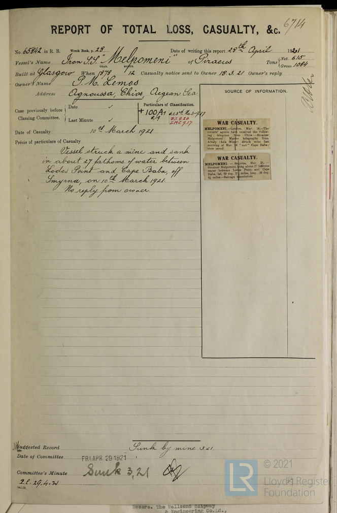
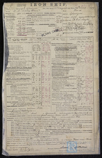
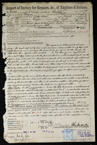
28/04/1921
The year in which a vessel’s construction is completed.
1878
The individual and/or organisation listed as having been responsible for constructing the vessel. This can/may be the same as the owner and/or manager.
A & J Inglis
The name of the yard where the vessel was built.
Pointhouse
Unique internal numbers used for identifying, referring and retrieving a specific survey report.
6714
Records that constitute Lloyd’s Register’s first official encounters with a specific vessel, e.g. a survey report.
N
Classification symbol assigned to a vessel by Lloyd’s Register’s Classing Committee denoting the quality of construction and maintenance.
+100A1 8.19; ss 3rd no3 9.17; in red BS 8.20 LMC 9.17
A vessel’s means of propulsion.
Steam
A ship’s total internal volume in ‘register tons’ (replaced by gross tonnage post 1982).
1084
Tonnage derived by deducting from the gross register tonnage the capacity that in unavailable for cargo, e.g. machinery space, fuel, crew accommodation etc.
615
Location of construction for a vessel’s engines.
Glasgow
Confirmation as to whether the vessel was equipped with refrigeration machinery to aid in the transport of frozen or chilled cargo/goods.
No
Does the vessel possess an auxiliary power source?
No
Is electric lighting fitted to the vessel?
No
Used to indicate the capability of early reciprocating steam engines, based on dimensions rather than performance. It is not a true indication of actual engine power.
206
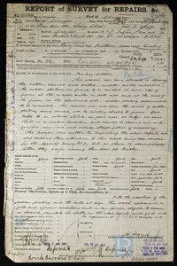
Contextual information related to the reasons of the vessel’s loss or disposal.
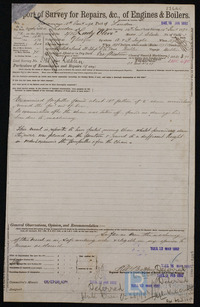
She struck a mine and sank in about 27 fathoms of water between Lodos Point and Cape Baba, lat 39 deg 27 1/2 miles long 26 deg 6 1/2 miles
Recorded date for the vessel’s loss or disposal.
10/03/1921
Also referred to as extreme breadth. The distance from the extreme starboard side to the extreme port side.
30.3
Physical extent of a record.
1
Name of ship as recorded on the record
Lady Olive
The process of transferring a vessel to water, but not necessarily her completion.
10/12/1878
Unique identifier for a given ship, it is assigned by a builder.
150
The port or place in which the vessel’s construction took place, at the time of writing.
Glasgow
Official administrative title (often printed) of a record used by Lloyd’s Register or external organisations.
Report of Total Loss, Casualty, &c./ Wreck reports
The individual and/or organisation listed
P M Lemos
Broad categories and subdivisions of vessels related to their purpose or function.
undefined
Is the steamer assisted by sail?
No
A ship’s total internal capacity of a ship measured in register tons from the top of the floors to the tonnage deck.
850
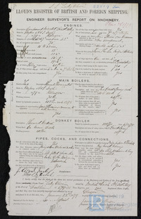
Type and configuration of the engine(s) supplied for a vessel.
Compound engine, 2 cylinders
A & J Inglis Ltd
Is machinery fitted at the aft of the vessel?
No
Generally a smaller additional auxiliary boiler (often used while the vessel is at port).
No
Name of the Proving House responsible for the public testing and certification of a vessel’s anchors and/or chain cables.
No
The official record pronounced by the Committee
Sunk
Vessel’s area of loss or disposal/last known recorded location.
Between Lodos Point and Cape Baba
Prescribed by flag/registration authorities, and usually excludes a small part of the stern. It is measured from the foreside of the stern at the extreme top to the afterside of the stern post.
249.8
Measurement from the underside of the upper deck on the centre line to the upper side of the bottom plating.
15.9
Report an issue with this document
Have you noticed missing or incorrect data or images for this document?
Please let us know and we will rectify the issue as soon as possible.